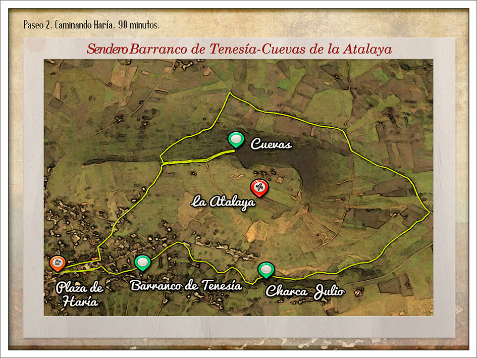
Tenesía precipice pathway Caves of Atalaya
Hike number 2 – Stroll in Haría.
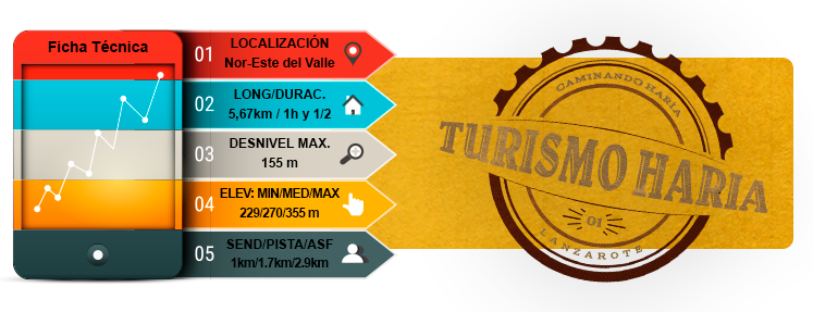
Features
Preferred
- TOTAL TIME: 1 h 30 min
- DEPARTURES: Haría square
- ARRIVALS: Haría square
- LEVEL: Easy
Introduction
- The itinerary goes down through the Tenesía precipice and around the base of the Atalaya volcano, which we will access by a slightly upward slope before reaching Máguez. Then we’ll go through the carved caves before returning to the village.
- The Tenesía precipice is part of the village. One could say it lives below Haría. The visitor perceives its presence through the existence of wide canals that appear and disappear in the streets, seemingly without continuity. We enter the precipice through an alley with a picturesque well, home of overflowing but imperceptible life, that hides us among stone walls, palm trees and cultivation terraces. Further, there is a pond from which leaves an irrigation canal which then leads to a lake, in-between high natural stone walls covered with lichen.
- Leaving the Precipice, we will walk a stretch of road towards Máguez. During this trip, the abrupt volcanic landscape around us is the result of several rounds of eruptions, combined with the peaceful and tidy aspect of the traditional cultures.
- From there, one can enjoy the majestic Corona volcano, essential icon of non-historical eruptions, that arises from the Macizo de Famara itself, thus giving birth to the extraordinary Malpaís of Corona. The Malpaís then heads East and extends to the sea to form the Verdes cave tunnels as well as the Jameos del Agua. The ascent is done by the Atalaya mountainside up to the carved caves, from which we can observe the villages of Máguez, Arrieta, Punta Mujeres and Mala.
Routes
Haría square
La Hoya Street
San Juan Street
Barlovento Street
Downhill Tenesía precipice
Exit to the road (LZ-206) towards Máguez
Entrance to the left, signposted trail GR 135, just before reaching the Máguez village
Once at the summit of Atalaya, take the dirt track on the left towards the caves and the belvedere
Come back and go down towards Haría on dirt roads until the road
Molino street, arrival behind the church and entry in the square
MAP 2
DOSSIER GUIDE PDF
STROLL IN
Map in Google Earth
- If you do not have the free software Google Earth, you can download it from earth.google.com
- Download the route 2 in Google Earth format.(Kmz)
- Click the right button of your mouse on the track to see the elevation profile. Then click on “show elevation profile”.