WALKING GUINATE
Walk 6 – Walking Haría.
Features
Recomendado
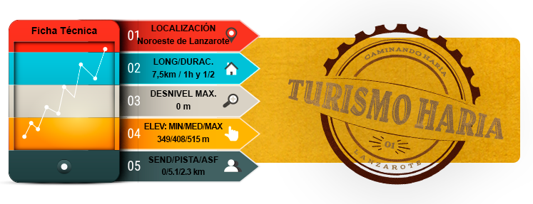
- Total time: 1 h 30 min
- Start: Guinate
- Finish: Guinate
- Difficulty: Very easy
Introduction
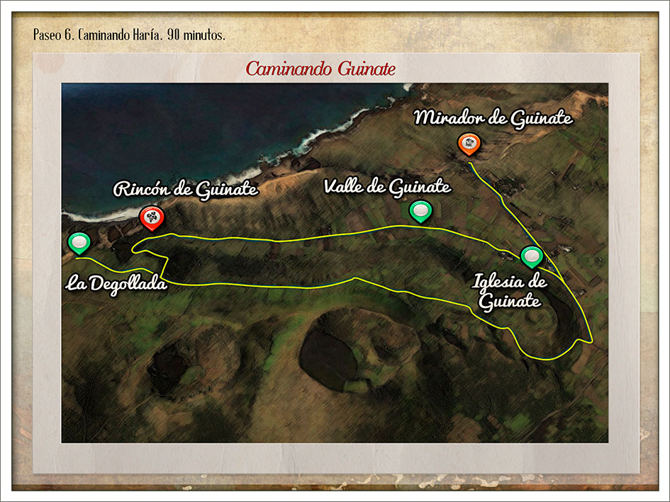
- Guinate, one of the highest villages in the north of the island, stands at some 500 metres above sea level overlooking a valley of the same name and on the edge of the Famara Massif cliffs.
- The walk begins by heading towards the Mirador de Guinate outlook, from where you can see the island of La Graciosa and the smaller islands of Montaña Clara, Alegranza and Roque del Oeste that complete the Chinijo Archipelago.
- After enjoying the view, head back to the village and the Iglesia de Nuestra Señora de Lourdes.
- Walk along the dirt track through the valley leading to the sand-covered cropland owned by residents and farmers.
- You will eventually arrive at Rincón de Guinate, with the Jorado mountain to the right and the Cerca mountain to the left.
- Ascending the Degollada, you will reach the Fuentes de Gayo springs - of great importance to water supply on the island. Continue along the same path to reach the edge of the cliffs near Gayo for some impressive views of the south-west of the island.
- Heading back along the same dirt track, continue along the Camino de las Calderetas in a straight line below the Quemada (560m) and Helechos (584m) volcanoes, which form part of the line of volcanoes that shaped the northern landscape of Lanzarote and continues southward towards the Timanfaya volcanoes and their much more recent eruptions.
- Keep going towards the Calderetas (430m) volcano, descending one side of the mountain to reveal the unmistakable Corona volcano almost in front of you, as you return to the village of Guinate.
Route
Mirador de Guinate outlook
Guinate village
Iglesia de Nuestra Señora de Lourdes
Valle de Guinate
Rincón de Guinate
La Degollada
Fuentes de Gayo
Camino de las Calderetas / Quemada Volcano
Camino de las Calderetas / Helechos Volcano
Camino de las Calderetas / Calderetas Volcano
MAP 6
DOSSIER GUIDE PDF
WALKING
Map in Google Earth
- If you do not have the Google Earth software, it can be downloaded for free at earth.google.com
- Download The route for “Walk 6” to view it in Google Earth.(Kmz)
- To see the elevation profile, right click on the route and then click Show elevation profile