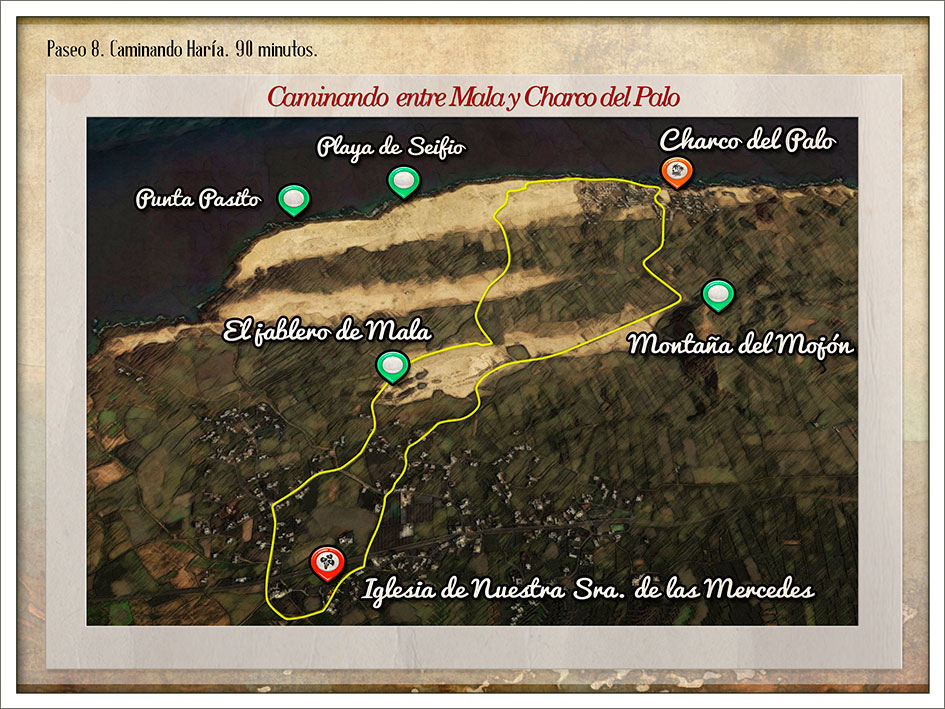
WALKING MALA AND CHARCO DEL PALO
Walk 8 – Walking Haría.
Features
Preferred
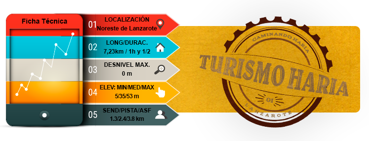
- Total time: 1 h 30 min
- Start: Iglesia de Ntra. Sra. de las Mercedes
- Finish: Iglesia de Ntra. Sra. de las Mercedes
- Difficulty: Very easy
Introduction
- This northern town is surrounded by large prickly pear plantations and takes you back to a time when the local inhabitants lived off “cochineal beetles”. Together with the barilla and orchilla plants, they were used heavily for trade to make up for the lack of resources on an island with little rain.
- Head towards the main road from Iglesia de Nuestra Señora de las Mercedes and cross over to Calle Tenegüime. Continue along this road between the houses and crops towards an area used to grow prickly pears.
- Eventually, the landscape and land itself will start to change as you reach the sand. Following the road towards Charco del Palo, you will come across a reddish rock from which people extract rofe or lapilli, the Montaña del Mojón mountain.
- A short distance into Charco del Palo, you will find a car park and a small park revealing a series of sandy paths to the right dotted with barrilla plants that trace out some odd-shaped paths down to the bathing areas and spots for enjoying the coast.
- This part of the walk follows a path along white sand beside low cliffs towards the Charco del Palo natural pool. You will see several other bathing spots, as well as rocky outcrops and caves used by fishermen.
- Leaving the urban landscape behind, the walk continues into a wild coastal area to cross up to three swathes of white sand intermittently mixed with areas of lapilli and plots used for growing plants.
- Follow Calle de la Marejeta towards Jablero de Mala. Here you can observe an impressive quarry stemming from the extraction of material, mainly for construction. However, saltpetre conditions meant the material was not as good as first thought so extraction activity has stopped.
- Head back to where you started through the streets of Mala and its white houses and impeccable gardens.
Route
Iglesia de Ntra. Sra. de las Mercedes
Calle Teneguime – Calle El Jable
Road to Charco del Palo – Montaña del Mojón
Charco del Palo
Mala quarry
MAP 8
DOSSIER GUIDE PDF
WALKING
Map in Google Earth
- If you do not have the Google Earth software, it can be downloaded for free at earth.google.com
- Download the route for “Walk 8” to view it in Google Earth.(Kmz)
- To see the elevation profile, right click on the route and then click Show elevation profile