WALKING ARRIETA AND TABAYESCO
Walk 7 – Walking Haría.
Features
Preferred
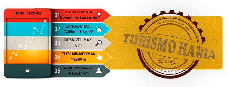
- Total time: 1 h 30 min
- Start: Playa de La Garita
- Finish: Playa de La Garita
- Difficulty: Very easy
Introduction
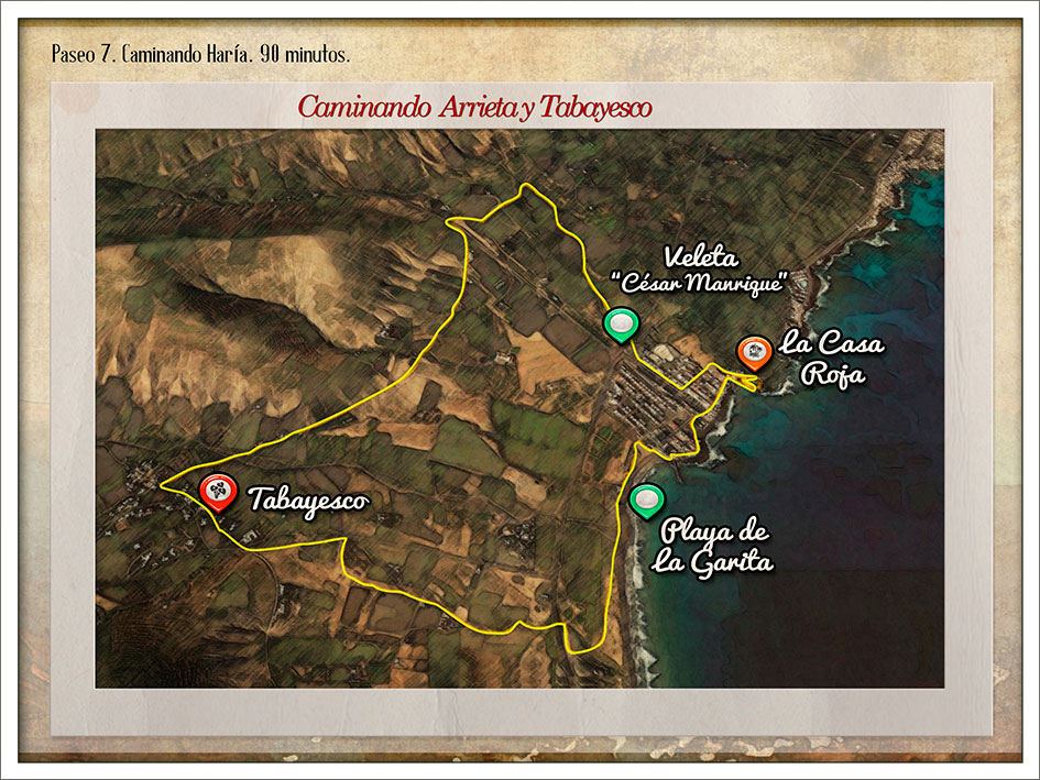
- The Playa de la Garita beach, in the town of Arrieta, is the starting point for this walk. You will return here after discovering a route that introduces two extremely important aspects of life on this island: the coast and the interior.
- From the beach car park, head towards the town along the end of the Playa de La Garita beach.
- Continue along the streets of Arrieta to reach what could be called the town centre, where most of the businesses, shops, bars and, above all, restaurants can be found.
- Head towards the Muelle de Arrieta pier next to the diminutive Playa del Charcón beach and a building that stands out from the usual Canarian architecture found on the island but to which the island’s inhabitants have grown very accustomed. Casa Roja, Casa China or Chalet de Arrieta are the names most often used to refer to this building.
- From here, head over to the Iglesia de Nuestra Señora del Carmen and, at the end of the street, onwards along the avenue leading to the roundabout on the edge of town. On the roundabout you will see one of the beloved Wind Sculptures by the artist from Lanzarote, César Manrique, called “Veleta”.
- Cross the main road to continue along the dirt track that follows the Barranco La Negra ravine. After a few metres, the path enters the ravine itself and continues.
- Eventually, the path turns left towards the road. Cross the road and follow the dirt track towards the Barranqueras de Tegaso and the Valle de Temisa to reach the town of Tabayesco.
- Head down the road back towards Arrieta but turn right at the Barranco de Seña Luciana ravine to reach the Playa de La Garita beach from the opposite direction to which you started.
Route
Playa de la Garita
Arrieta town centre
Arrieta pier
Casa Roja / Casa China / “El Chalet de Arrieta”
Iglesia de Nuestra Señora del Carmen
César Manrique’s “Veleta” Wind Sculpture
Road / Barranco La Negra ravine
Barranqueras de Tegaso
Tabayesco
Mouth of the Barranco Seña Luciana ravine
MAP 7
DOSSIER GUIDE PDF
WALKING
Map in Google Earth
- If you do not have the Google Earth software, it can be downloaded for free at earth.google.com
- Download the route for “Walk 7” to view it in Google Earth.(Kmz)
- To see the elevation profile, right click on the route and then click Show elevation profile