WALKING PUNTA MUJERES
Walk 4 – Walking Haría.
Features
Preferred
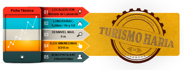
- TOTAL TIME: 1 h 30 min
- Start: Los Morros
- Finish: Los Jameos del Agua
- Difficulty: Very easY
Introduction
- Walkers will lose sight of the sea on very few occasions during the course of this entirely coastal walk. So the route provides a great opportunity to discover several off-the-beaten-track paths down to the sea for a peaceful dip, water sports or fishing and shell fishing activities.
- Furthermore, the Jameos Site of Scientific Interest forms part of the Corona Volcano and Corona Badlands Natural Park and is of particular interest as an area of special ecological importance that is home to various endemic species.
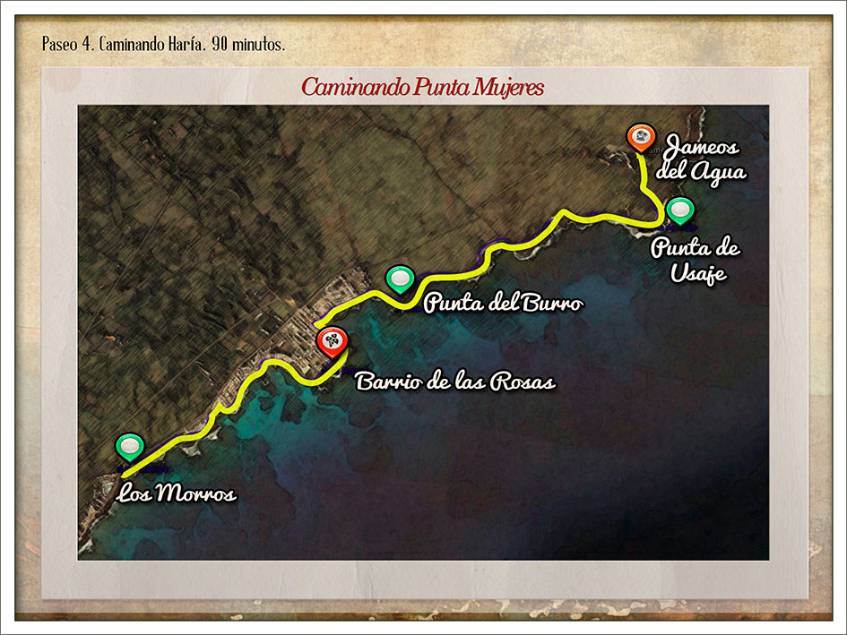
- This linear coastal route begins by walking along an open avenue flanked on one side by the sea and volcanic rocks covered in tabaiba bushes on the other. After walking through the Los Morros district, you enter the town of Punta Mujeres proper via the area known as El Bajo el Espino. The houses here are known for their gardens or terraces leading right down to the shore.
- This town sits right on the coast and walkers can enjoy the Punta de los Picachos (or Punta de las Mujeres) and the Punta de las Rosas, rocky outcrops that extend into the ocean. The area now occupied by the Las Rosas district was once used as the Ventura salt flats.
- Continue walking along the coastal roads of the town to reach Punta del Burro, another rocky outcrop. As you leave the town behind, the route begins to follow a path of sand, dirt and volcanic rock, bringing you into full contact with this unique natural coastal environment. The path winds its way through the badlands and volcanic rock spewed out by the Corona Volcano, lava that poured into the sea and is now dotted by tabaiba bushes as a fine example of vegetation that can withstand the onslaught of salt water from the ocean. Keep following the path to eventually reach the Jameos del Agua Tourism Centre.
- From here, this walk returns back along the same path to finish where you started.
Route
Los Morros
La Juradita
Pools
Caleta de Seña Bárbara
Las Rosas district
Playa de la Seba beach
Punta del Burro
Los Caletones del Burro
La Lajita or Punta de Usaje (Los Jameos Site of Scientific Interest)
Los Jameos del Agua
MAP 4
DOSSIER GUIDE PDF
WALKING
Map in Google Earth
- If you do not have the free software Google Earth, you can download it from earth.google.com
- Download the route 4 in Google Earth format.(Kmz)
- Click the right button of your mouse on the track to see the elevation profile. Then click on “show elevation profile”.